
6,200 BCE to 600 CE
33 Monographs (#100-#121)
180 Images/458 pages

600 to 1300 CE
75 Monographs (#200-#226)
450 images/1,324 pages

1300 to 1500
49 Monographs (#227-#261)
370 Images/1,081 pages

1492-1800
190 Monographs (#300-#800.8)
700 Images/2,444 pages

Last Updated: 22 June 2024 (33 pages)

The Depiction of Cities on Early Maps
Original: 14 December 2012 - Last updated: 2 May 2025 (141 pages)

When America was part of Asia for 270 years
Original: 20 April 2015 - Last updated: 11 May 2024 (127 pages)

Original: 9 August 2016 - Last updated: 12 August 2025 (132 pages)

Old Maps with the Great Wall of China
Original: 9 August 2016 - Last updated: 12 September 2025 (153 pages)

Original: 22 April 2016 - Last updated: 22 September 2025 (104 pages)

Original: 22 April 2016 - Last updated: 22 June 2025 (12 monographs)
A Survey of Anthropomorphic Maps
Original: 3 May 2016 - Last updated: 22 June 2024 (172 pages)

The Concept of the Antipodes in Maps
Original: 27 June 2018 - Last updated: 22 June 2025 (75 pages)

The Origin of the Continents & the Display of Countries
Original: 24 November 2014 - Last updated: 2 June 2024 (105 pages)

Indigenous People on Early Maps
Original: 9 October 2018 - Last updated: 22 August 2025 (167 pages)

Original: 9 August 2016 - Last updated: 22 June 2025 (246 pages)

Opening & Closing the Indian Ocean
Original: 2 February 2017 - Last updated: 22 June 2024 (72 pages)
Original: 1985 - Last updated: 22 June 2025 (326 pages)

Original: 1985 - Last updated: 2 June 2025 (156 pages)

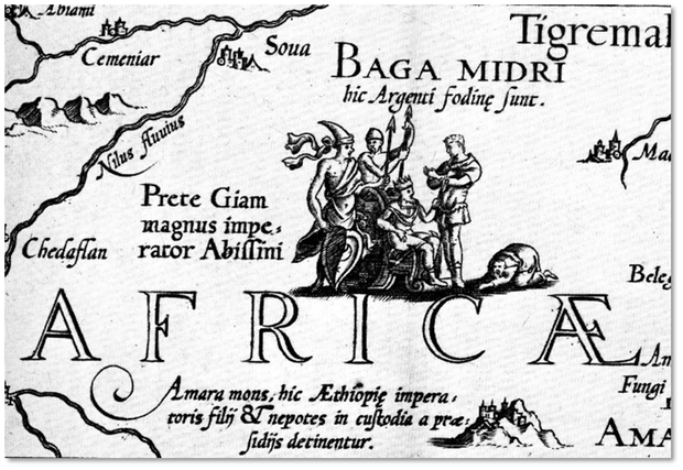
The Evolution of Africa in Early Maps
Original: 3 November 2017 - Last updated: 22 August 2025 (259 pages)

The Evolution of the Polar Regions in Early Maps
Original: 22 April 2021 - Last updated: 22 April 2025 (320 pages)

Original: 24 December 2017 - Last updated: 12 August 2025 (46 pages)
The Evolution of Florida in Early Maps
Original: 2 February 2018 - Last updated: 22 August 2025 (111 pages)

The Evolution of Japan in Early Maps
Original: 21 March 2018 - Laste updated: 22 August 2025 (233 pages)

The Evolution of South America on Early Maps
Original: 2 April 2018 - Last updated: 22 June 2024 (157 pages)

Creatures on Maps: Real and Imagined
Original: 17 May 2018 - Last updated: 22 April 2025 (202 pages)

The Evolution of Greenland on Early Maps
Original: 9 October 2018 - Last updated: 12 August 2025 (176 pages)

The Evolution of the British Isles on Early Maps
Original: 20 August 2018 - Last updated: 12 August 2025 (138 pages)

Mythical Islands of the Atlantic:
Frisland, Antillia, Saint Brendan, Hy-Brasil, Thule
Original: 14 October 2018 - Last updated: 12 September 2022 (345 pages)

the Depiction of Paradise & the Garden of Eden on Early Maps
Original: 30 October 2018 - Last updated: 22 August 2025 (149 pages)

Four Cartographic Myths Explored:
California as an Island, Fusang, the Great Sea of the West
Original: 15 November 2018 - Last updated: 22 July 2025 (218 pages)

Original: 15 November 2018 - Last updated: 22 December 2024 (73 pages)

The Evolution of the Great Lakes on Early Maps
Original: 22 January 2023 - Last updated: 22 June 2024 (150 pages)

Original: 20 September 2019 - Last Updated: 22 August 2025 (607 pages)

The Evolution of the Caspian Sea on Early Maps
Original: 22 August 2020 - Last Updated: 22 June 2024 (129 pages)

The Evolution of the River Nile on Early Maps
Original: 2 September 2020 - Last Updated: 7 August 2025 (172 pages)

The Evolution of Texas on Early Maps
Original: 20 September 2020 - Last Updated: 22 August 2025 (106 pages)

The Evoution of the the Amazon River on Early Maps
Original: 20 September 2020 - Last Updated: 22 June 2024 (57 pages)
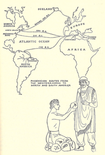
Pre-Columbian Atlantic Crossings
Original: 22 September 2025 (56 pages)
Original: 8 July 2015 - Last updated: 22 February 2025 (67 pages)

Cartographic Silence, Censorship, Propaganda, Horror vacui and Lies on Old Maps
Original: 2 November 2020 - Last Updated: 22 June 2024 (56 pages)

Last Updated: 22 July 2025 (27 monographs)
If you have specific questions or comments about this site you can contact me at: jsiebold@me.com
Established 1994 (via Henry Davis Consulting)
Re-Established 2010 (Cartographic-images.net)
Current website version established 2015
From 2023 with support from the CartoPhilatelic Society
Site Last Updated: 22 September 2025
I obviously love maps. I do not collect “originals” anymore, unless you count the ones in the box under my desk, which I've saved as souvenirs from the cities they walked me through or cross-country trips they guided.
The maps I covet - early renderings of the known world before the New World came to light, mariner's portolans bearing wind roses, those with beautiful cartouches, land and sea creatures and indigenous people - are all beyond my means, anyway.
They belong where they are, in museums and libraries, for everyone to admire, not confined to the (limited) walls of my house.
Digital images of the “originals” and good facsimiles/reproductions are enough to excite me and allow me to pursue my research.
The CartoPhilatelic Society, collectors of maps on stamps, who use old maps in their philatelic research activities will be supporting this site to keep it operational well into the future.

One of the foremost geographers of the 20th century, Professor Gaetano Ferro1 (1925-2003), late Professor of Geography and President of the Italian Geographical Society, wrote in 1996 the following: Cartographic documents of the past cannot be adequately studied and understood unless one first takes into account the culture that they express (and the methods by which they were constructed), on the one hand, and the aims and objectives for which they were intended, on the other. In other words, the depiction of the earth, and its evolution, are part of a system of thought and communication that is tied to, and a function of, the different eras and their means of expression. Within this perspective it is possible to overcome the ancient and deep-rooted habit of appraising the cartographic document of the past only according to whether it corresponds to geographic reality as we know it today, or better yet, whether it conforms to the mathematical rules of modern science, which governs how such a reality is to be represented.
as of 2 September 2025 this site contains ~ 11,467 pages
[ ]