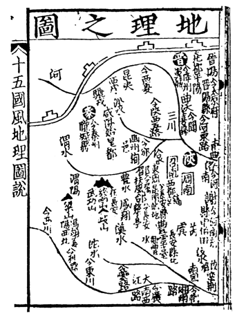
TITLE: Ti Li chih T’u
DATE: 1155 A.D.
AUTHOR: unknown
DESCRIPTION: Another of the many technological milestones that can be attributed to
the Chinese culture is the production of the earliest known printed map. This distinction
originally belonged to Ti Li chih T’u [a map of West China] which serves as an
illustration in the Liu Ching T’u [Illustrations of Objects Mentioned in the Six Classics],
an encyclopedia edited by Yang Chia. Since 1973, however, the Han maps (Book I, #112.1)
dating from before 168 B.C. are now considered the first, thereby predating the first map
printed in Europe by over five centuries (1472, #205).
The Ti Li chih T’u is printed in black ink on paper (a medium which had been invented in China in about 105 A.D. and accredited to Ts’ai Lun) and depicts part of western China. Provincial names are indicated here in white on black, with additional settlements, rivers, and a portion of the Great Wall all illustrated in black ink. It is oriented to the North, a convention standard in modern maps but certainly not common in medieval Europe whose cartographic efforts during this time were dominated by religious themes, oriented to the East, highly schematic and with a predilection for fabulous mythological characters. Arabic maps were normally oriented with South at the top. Thus, this very early printed map, though somewhat crude, shows no tendency to compress the topography into an artificial disc-like form, and confines itself to the practical setting-down of the characters of place-names.
LOCATION: Beijing National Library
REFERENCES:
*Chang, Kuei-sheng, “The Han Maps: New Light on Cartography in classical China”,
Imago Mundi, Volume 31 (1979), pp. 9-17.
*Needham, J., and Ling, W., Science and Civilisation in China, volume 3, pp. 549-550,
Figure 227.
*Thrower, N.J., Maps and Man, pp. 24-26. *illustrated
Last Updated: 4 November 2015
Ti Li chih T’u, 1155, the EARLIEST printed map